Search This Blog

Showing posts with label Apache. Show all posts

Friday, March 23, 2018

Who Gets to Name Places?


Sunday was another cold, windy, chilly day, too cold to sit and drink coffee on the porch at Beverly's and watch trains go by. Go to La Unica for lunch? No, esta cerrada los domingos. (Sorry about those missing accents!) Another nearby wonder our friend Joe had never visited, however, was the Amerind Foundation Museum, over the other side of Texas Canyon, and yes, the museum was open until 4 p.m., so off we set. 

I had already been twice to the museum and was more in need of a little quiet reading time than another exhibit walk-around, so I waited in Joe's truck, luxuriating in warm sun through the windows, while he and the Artist took in the exhibits. One of the books I bought from Winn the other day on the Benson book-buying excursion was Wisdom Sits in Places: Landscape and Language Among the Western Apache, by Keith H. Basso, and Chiricahua on Saturday and Texas Canyon on Sunday were the perfect backdrop for Basso's book, as his purpose in these essays -- as in the research preceding their writing -- was to understand the significance of place-names in Apache life and thought. For too long, Basso writes, linguists have considered place-names exclusively as referrents, regarding them within the larger range of proper nouns "as referential vehicles whose only purpose is to denote...." He notes the irony of this position,

...for place-names are arguably among the most highly charged and richly evocative of all linguistic symbols. Because of their inseparable connection to specific localities, place-names may be used to summon forth an enormous range of mental and emotional associations--associations of time and space, of history and events, of persons and social activities, of oneself and stages in one's life. And in their capacity to evoke, in their compact power to muster and consolidate so much of what a landscape may be taken to represent as both personal and cultural terms, place-names acquire a functional value that easily matches their utility as terms of reference. 
- Keith H. Basso, Wisdom Sits in Places: Landscape and Language Among the Western Apache (Albuquerque, NM: University of New Mexico Press, 1996)

Because of the evocative power of place-names and their freight of associations, they also make available rich metaphorical meanings that native speakers use in story-telling. It felt good to sit quietly and soak in warm sun and rich ideas.


When my expedition companions returned from their museum tour, the Artist directed our friend to drive to the picnic grounds, where amidst seemingly gravity-defying boulders (many, I have discovered from close examination, have vestigial mushroom-like stems connecting them to base rocks) the three of us deployed cameras like the tourists we were. 


The edge of Texas Canyon encompassing the Amerind and lining Dragoon Road is certainly spectacular, and Joe was especially entranced, seeing it up close for the first time, but I couldn't help relating the place to my reading and thus thinking that surely it once had an Apache name, a name that would have been very important to the people who knew and used it. The entirety of Texas Canyon would have had such a name, and the smaller area we were photographing no doubt -- the feeling was very strong; I was sure of it -- had its own specific name, a name would hold for its people a history of events to which we visiting Anglos are completely blind. 


We can read all we want about the geology of the area, how the rocks came to be, as they are, but we have no personal connection to the place, no memories of unwritten local events, no knowledge of the stories that would make the rocks live for those knowing the stories. We are only strangers passing through a place named on our paper maps. 


Back on the road, though, from our passage through Texas Canyon on the expressway, I could see Dos Cabezas in the distance, and I thought, those twin peaks are my mountains. I look out on them every morning. They are the landmark from which I orient, whatever direction we travel out from our winter cabin to go elsewhere. Those mountains have become part of my life, whether hidden in clouds or mist, standing out bright in the first light of morning, or darkening as night comes on. I smiled, seeing Dos Cabezas -- and again, a little farther down the road, when Willcox appeared, "my little cow town," as I call Willcox, feeling a fondness for an endless number of ordinary spots and corners in the town, places now woven into my life history and meaningful to me, even from my ephemeral position on the far periphery of local culture.

Most of the town names around here are not awe-inspiring or evocative of very much. Willcox, Benson, Pearce, and Safford are named for whitemen who were at one time big deals but are hardly household names any more. Texas Canyon is called that because some a family from Texas got no closer than this to their original destination, the West Coast. The name Cochise County, when you get right down to it, is only the name of a person — albeit an Apache — not the kind of specific, descriptive place-name Apaches themselves would have used. 

Dos Cabezas, the name of a small mountain range, its twin peaks, and also the ghost town nestled on the south side of those peaks, comes nearer the spirit of Apache place-naming. As one of Basso's informants said of her home mountain: "'Elsewhere, hearing that mountain's name, I see it. Its name is like a picture.'" That is certainly true of Dos Cabezas. Its name is like a picture, and whenever I see or hear the name, I see the mountains, their identifying twin peaks, and the ghost town below, and my impulse is to pronounce the name aloud. 

In Dos Cabezas, our little poblado del invierno, I feel like more than just a stranger passing through. However temporary our stay, I feel at home here. 


Friday, January 30, 2015

Climbing Into the Sky


Within the fixed limits of its allotted hours the sun is supreme. It does not yield to passing clouds, for much of the time there are none. Nothing can deny the sun’s omnipotence or detract from its authority. Step into its presence and you are flooded with light. All the world around you is immersed in its radiance. 
- Walter Collins O’Kane, The Intimate Desert
In the morning, we went to town (Willcox, that is) to do errands, winding up with coffee on the front porch of our regular coffee spot before coming home for lunch, so it was nearly midafternoon before we set off on our first visit to nearby Chiricahua National Monument. Only 21 miles from Dos Cabezas, the trip took us east of home on 186 for the first time.


It was exciting to see snow-capped mountains ahead in the distance and to know that was our destination for the day. Clouds – yes, that day there were clouds -- made constantly shifting dark shadows on the mountains and intervening seas of grass, the grass tall and golden under a bright blue sky like the coat of an immense animal covering many square miles.


We hadn’t gone far into the park when a roadrunner suddenly appeared and ran crazily along the road, zig-zagging in our direction, before disappearing again into the vegetation. At the visitor center, I mentioned it to the ranger, prefacing my reportage, “This probably won’t sound thrilling to you...,” but she said it was thrilling, because “we don’t get a lot of roadrunners up here.” More luck! And it kept coming, too, because Chiricahua no longer charges an entry fee. I put the money saved toward part of the price of a state road atlas from the gift shop. I like maps with detail, with every dirt road shown.

But this day was all Chiricahua. And here, in large part, is the text from the first informational sign we encountered:
The Apache called this area “The Land of Standing-Up Rocks”....  
Chiricahua resembles an oceanic archipelago – a sea dotted with islands – only here the desert is a hot desert grassland. We call these isolated mountain ranges “sky islands.” The Sonoran and Chihuahuan deserts, and the Rocky Mountain and Sierra Madre ranges all meet here. The convergence of these four homes makes the area unusually rich in biodiversity. 
Chiricahua National Monument was established in 1924 to protect the fantastic rock formations known as “the pinnacles.” In 1934 the Civilian Conservation orps began the job of improving the road and constructing the trails and many park structures, including the visitor center. 
In 1976 Congress decided to further preserve the land by designating 86% of the monument as Wilderness. This precludes any development and human intervention, thus ensuring the preservation of the geological formations for future generations. 
Another 6 miles along the Bonita Canyon Drive will transport you through oak, cypress and pine forests to the summit at Massai Point, where you will get a true sense of being atop a sky island.
And so we set off, up the mountain road. It was not at all easy to photograph the “standing-up rocks,” either with the light directly on them, so that they tended to be overexposed relative to surrounding sky and trees, or when they were plunged into deep shade and the sky behind them flooded with light. I thought Photoshop would save me, but success was elusive – limited, at best.


Also, as the road climbed more and more steeply, my anxiety got in the way of camera work, too. I kept asking David to slow down. He wasn’t driving fast, and he was driving very well; it just felt fast and scary to me. Lucky (again) that I hadn’t known ahead of time how terrifying the road up to Massai Point would be, with all those drop-off edges, or we might have missed some these heart-stopping long-distance views.


Again, sharp contrasts of light and dark made it impossible (for me, I should say; suggestions are welcome) to capture both nearby mountain rocks and lowlying background rangeland together. Try imaginatively to put together in your mind’s eye the two photographs above to see what we actually saw.

But we were really there, 6,870’ above sea level! Some peaks in the Chiricahuas, I should note, are higher than 9,000’, but almost 7,000 is as high as I feel the need to go!


Can you tell I was quaking in my boots? And doesn’t David look relaxed?


We met a couple from Louisiana, painters who now live in Benson, Arizona, not far from Willcox. David talked painting with them. Sharon and I compared geographical notes. Looking off in the direction I correctly identified as northeast, she told me we were looking toward the Gila range and New Mexico. The light in that direction was kind and gentle.


The name for the geology of this SE corner of Arizona is range and basin (yes, as in John McPhee’s book title), and I admit I’m more comfortable in the basins or in the foothill regions between basin and peaks. Coming back down from the dizzying heights, when I was able to look up at the rocks again and feel more comfortable, we found a picnic spot and caught our breath and ate apples and drank water and spotted an acorn woodpecker high in a tree. The acorn woodpecker is “common,” but it’s the first one I’ve ever seen, so it was thrilling to me, and I’m including its picture, despite the poor quality of the image.


The light was gentle as we left the mountains behind. We will return often to the Chiricahuas, I’m sure. It is very close and very beautiful. Also, there is a lot to explore at my preferred lower altitudes.


(Looking back)

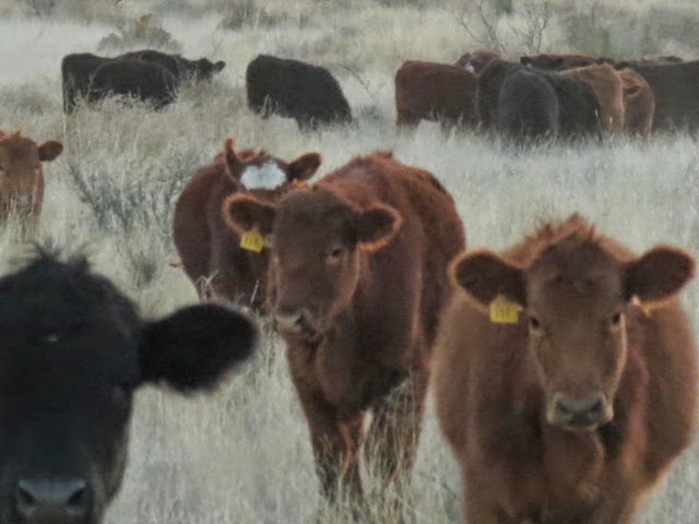
On our way back west, I wanted to stop to get a better look at some grazing “cows,” as all cattle (mostly steers) are called out here. When I got out of the car, the animals ambled over to the fence, seemingly curious.


All are curious and want to get in on the action!

Blue sky with clouds, golden grasses, a lovely new stretch of road with almost no traffic, a roadrunner, fantastic mountains, terror, delight, beauty, an acorn woodpecker, and cattle up close -- what more could such a beautiful, thrilling day offer, if not a spectacular sunset from our front door in Dos Cabezas?